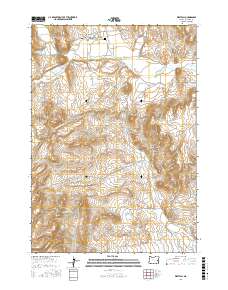
2017 Map of Westfall
USGS Topo · Published 2017About this map
Westfall and Harper anchor this high-desert landscape in Malheur County, where the settlement pattern is dictated by water and topography. The northern reaches of the map are defined by the convergence of Bully Cr and Clover Creek Rd near the Westfall Cem. Traveling south, the terrain becomes increasingly complex, marked by prominent landmarks such as Danger Point and the drainages of Willow Spring Cr and Hart Cr.
Find a feature on this map
36 named features on this map. Tap any name to fly to it.
Don’t see what you’re looking for? This feature index may not catch every label — zoom into the map to look around manually.
Map Details
Editions of this 2017 Westfall Map
This is the sole edition of this map. No revisions or reprints were ever made.
Other maps of this area

1955 · Baker
USGS Topo · 1:250,000

1955 · Boise
USGS Topo · 1:250,000

1958 · Boise
USGS Topo · 1:250,000

1959 · Baker
USGS Topo · 1:250,000

1962 · Boise
USGS Topo · 1:250,000

1964 · Brogan
USGS Topo · 1:62,500

1966 · Clover Creek Ranch
USGS Topo · 1:62,500

1966 · Harper
USGS Topo · 1:62,500

1966 · Westfall Butte
USGS Topo · 1:62,500

1980 · Brogan
USGS Topo · 1:100,000