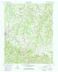
1958 Map of Westmoreland
USGS Topo · Published 1979About this map
The Louisville and Nashville railroad corridor anchors the western landscape of this mid-century survey, passing through the town of Westmoreland as it navigates the dissected plateau of the Sumner and Macon county line. The terrain is defined by a dense network of hollows, such as Stillhouse Hollow, Sugar Camp Hollow, and Hanging Rock Hollow, which dictated the placement of early rural settlements and farmsteads.
Find a feature on this map
73 named features on this map. Tap any name to fly to it.
Don’t see what you’re looking for? This feature index may not catch every label — zoom into the map to look around manually.
Map Details
Editions of this 1958 Westmoreland Map
2 editions found
Other maps of this area

1928 · Adolphus
USGS Topo · 1:48,000

1931 · Lafayette
USGS Topo · 1:62,500

1931 · Adolphus
USGS Topo · 1:62,500

1942 · Gallatin
USGS Topo · 1:100,000

1954 · Petroleum
USGS Topo · 1:24,000

1954 · Holland
USGS Topo · 1:24,000

1954 · Adolphus
USGS Topo · 1:24,000

1955 · Bethpage
USGS Topo · 1:24,000

1956 · Nashville
USGS Topo · 1:250,000

1958 · Westmoreland
USGS Topo · 1:24,000