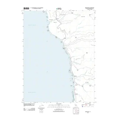
2012 Map of Westport
USGS Topo · Published 2012About this map
Westport and the northern Mendocino coast appear here in a landscape defined by steep ridges and complex coastal drainage systems. Small settlements like Rockport and Hardy are positioned where narrow valleys and gulches meet the Pacific Ocean, reflecting a history of coastal commerce and resource extraction. The terrain is notably fractured, with numerous deep incisions such as Slaughterhouse Gulch and Jimmy Gulch carving through Cottaneva Ridge and Alviso Ridge. This geography dictated a linear development pattern, with infrastructure like Branscomb Rd and Howard Creek Rd navigating the difficult elevation changes between the shore and Bell Mountain. Landmarks like Cottaneva Needle and Cape Vizcaino provide prominent navigational points along a shoreline dotted with named hazards and outcrops, including Sea Lion Rock and Switzer Rock.
Find a feature on this map
55 named features on this map. Tap any name to fly to it.
Don’t see what you’re looking for? This feature index may not catch every label — zoom into the map to look around manually.
Map Details
Editions of this 2012 Westport Map
This is the sole edition of this map. No revisions or reprints were ever made.
Other maps of this area

1920 · Cummings
USGS Topo · 1:62,500

1921 · Westport
USGS Topo · 1:62,500

1921 · Branscomb
USGS Topo · 1:62,500

1950 · Piercy
USGS Topo · 1:62,500

1950 · Cape Vizcaino
USGS Topo · 1:62,500

1951 · Cape Vizcaino
USGS Topo · 1:62,500

1951 · Branscomb
USGS Topo · 1:62,500

1952 · Leggett
USGS Topo · 1:62,500

1957 · Ukiah
USGS Topo · 1:250,000

1960 · Ukiah
USGS Topo · 1:250,000