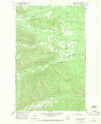
1966 Map of Whale Buttes
USGS Topo · Published 1971About this map
Flathead National Forest covers much of this high-elevation Montana landscape, defined by the prominent heights of Whale Buttes and Center Mountain. In the mid-1960s, this area remained largely primitive, with a network of Pack Trails serving as the primary means of navigation through the steep drainages. The hydrology of the region is centered on numerous tributaries that feed into the larger river systems, including the westward-flowing Whale Creek and the southern Hay Creek. Smaller waterways like Moose Creek, Hawk Creek, and the South Fork Red Meadow Creek carve deep valleys through the timbered slopes. Evidence of human infrastructure is sparse, limited to a single Gravel Pit in the northeast and light-duty roads that give way to the more traditional pack routes, reflecting the region's role as a managed forest wilderness during this era.
Find a feature on this map
12 named features on this map. Tap any name to fly to it.
Don’t see what you’re looking for? This feature index may not catch every label — zoom into the map to look around manually.
Map Details
Editions of this 1966 Whale Buttes Map
This is the sole edition of this map. No revisions or reprints were ever made.
Other maps of this area

1906 · Kintla Lakes
USGS Topo · 1:125,000

1913 · Stryker
USGS Topo · 1:125,000

1916 · Stryker
USGS Topo · 1:125,000

1938 · Kintla Lakes
USGS Topo · 1:125,000

1957 · Kalispell
USGS Topo · 1:250,000

1960 · Kalispell
USGS Topo · 1:250,000

1961 · Kalispell
USGS Topo · 1:250,000

1966 · Red Meadow Lake
USGS Topo · 1:24,000

1966 · Kintla Lake
USGS Topo · 1:24,000

1966 · Mount Hefty
USGS Topo · 1:24,000