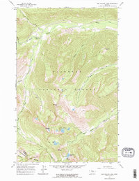
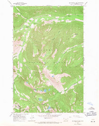
1966 Map of Red Meadow Lake
USGS Topo · Published 1970About this map
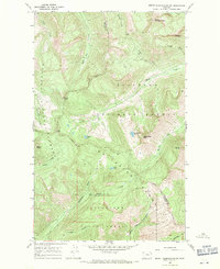
Flathead National Forest defines the high-altitude landscape of this mid-1960s survey, dominated by the peaks of the Whitefish Mountain Range. The area is characterized by a high-alpine water system, including the Chain Lakes and Red Meadow Lake, which serves as a central landmark for the surrounding Red Meadow area and its nearby Campground. Elevations reach their peak at Akinkoka Peak and Nasukoin Mtn, with the topography steeply dropping toward watercourses such as Whale Creek and its notable Whale Creek Falls. Infrastructure is limited to a network of primitive routes, including a Jeep Trail and several Pack Trails, illustrating the region's primary use for forest management and remote recreation. The boundary between Flathead Co and Lincoln Co traverses the southern ridges, marking a remote political division in the high country.
Find a feature on this map
23 named features on this map. Tap any name to fly to it.
Don’t see what you’re looking for? This feature index may not catch every label — zoom into the map to look around manually.
Map Details
Editions of this 1966 Red Meadow Lake Map
2 editions found
Other maps of this area

1906 · Kintla Lakes
USGS Topo · 1:125,000

1913 · Stryker
USGS Topo · 1:125,000

1916 · Stryker
USGS Topo · 1:125,000

1938 · Kintla Lakes
USGS Topo · 1:125,000

1957 · Kalispell
USGS Topo · 1:250,000

1960 · Kalispell
USGS Topo · 1:250,000

1961 · Kalispell
USGS Topo · 1:250,000
1966 · Bull Lake
USGS Topo · 1:24,000
1966 · Mount Hefty
USGS Topo · 1:24,000
1966 · Mount Thompson-Seton
USGS Topo · 1:24,000