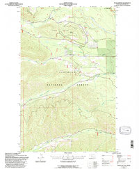
1994 Map of Whale Buttes
USGS Topo · Published 1997About this map
Flathead National Forest land dominates this 1990s terrain, where the northern Whitefish Range rises toward the Canadian border. The drainage network is the defining characteristic of this landscape, with Whale Creek and Moose Creek carving deep valleys around the prominent Whale Buttes and Center Mountain. In the northeast corner, the Flathead Wild and Scenic River forms a critical corridor, highlighting a period of increased conservation management for these waterways. The map documents a landscape defined by industrial access and recreational transit, showing numerous forest roads and trails that connect remote drainages like Red Meadow Creek and Hay Creek. A solitary Gravel Pit near the river reflects the localized materials used for maintaining these mountain routes.
Find a feature on this map
16 named features on this map. Tap any name to fly to it.
Don’t see what you’re looking for? This feature index may not catch every label — zoom into the map to look around manually.
Map Details
Editions of this 1994 Whale Buttes Map
This is the sole edition of this map. No revisions or reprints were ever made.
Other maps of this area

1906 · Kintla Lakes
USGS Topo · 1:125,000

1913 · Stryker
USGS Topo · 1:125,000

1916 · Stryker
USGS Topo · 1:125,000

1938 · Kintla Lakes
USGS Topo · 1:125,000

1957 · Kalispell
USGS Topo · 1:250,000

1960 · Kalispell
USGS Topo · 1:250,000

1961 · Kalispell
USGS Topo · 1:250,000

1966 · Red Meadow Lake
USGS Topo · 1:24,000

1966 · Kintla Lake
USGS Topo · 1:24,000

1966 · Mount Hefty
USGS Topo · 1:24,000