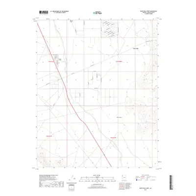
2018 Map of White Hills West
USGS Topo · Published 2018About this map
Detrital Valley dominates this arid landscape within the Mojave Desert, where the braided channel of Detrital Wash carves through the terrain. The settlement of White Hills is situated in the northeastern portion of the sheet, characterized by a planned street grid with thematic names such as Hitching Post Dr, Silverspur Dr, and Bonanza Dr. Further west, the Triangle Airpark represents a specialized community centered on aviation, evidenced by residential access via Cessna Dr and Mooney Dr. This modern survey illustrates a remote corner of Mohave County where transportation infrastructure, including Co Hwy 145, links dispersed residential developments through the broad alluvial basin.
Find a feature on this map
36 named features on this map. Tap any name to fly to it.
Don’t see what you’re looking for? This feature index may not catch every label — zoom into the map to look around manually.
Map Details
Editions of this 2018 White Hills West Map
This is the sole edition of this map. No revisions or reprints were ever made.
Other maps of this area

1886 · Camp Mohave
USGS Topo · 1:250,000

1892 · Camp Mohave
USGS Topo · 1:250,000

1926 · Nelson
USGS Topo · 1:96,000

1942 · Camp Mohave
USGS Topo · 1:250,000

1947 · Kingman
USGS Topo · 1:250,000

1948 · Kingman
USGS Topo · 1:250,000

1954 · Kingman
USGS Topo · 1:250,000

1955 · Kingman
USGS Topo · 1:250,000

1958 · Kingman
USGS Topo · 1:250,000
1959 · Mt. Perkins
USGS Topo · 1:62,500