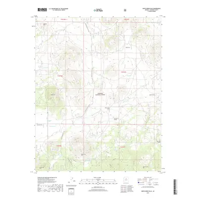
2018 Map of White Horse Hills
USGS Topo · Published 2018About this map
Coconino National Forest encompasses this high-altitude landscape north of Flagstaff, characterized by volcanic peaks and a complex network of livestock tanks essential for high-desert survival. The northern slopes of San Francisco Mtn dominate the southeastern corner, giving way to the prominent White Horse Hills and Saddle Mtn. The Arizona National Scenic Trail winds through the center of the sheet, providing a corridor for hikers through a terrain marked by deep washes like Deadman Wash and Whe-yol-da-sah Wash. Settlement is sparse, represented primarily by Kendrick Park, while the infrastructure is defined by forest roads and named water sources such as Walker Lake and Yellow Jacket Tank. This geography highlights the reliance on catchments and tanks in a region where seasonal runoff through Aubineau Canyon and Bear Jaw Canyon must be managed for grazing and transit.
Find a feature on this map
46 named features on this map. Tap any name to fly to it.
Don’t see what you’re looking for? This feature index may not catch every label — zoom into the map to look around manually.
Map Details
Editions of this 2018 White Horse Hills Map
This is the sole edition of this map. No revisions or reprints were ever made.
Other maps of this area

1886 · San Francisco Mtns
USGS Topo · 1:250,000

1891 · San Francisco Mtns
USGS Topo · 1:250,000

1894 · San Francisco Mtns
USGS Topo · 1:250,000

1899 · San Francisco Mtns
USGS Topo · 1:250,000

1908 · Flagstaff
USGS Topo · 1:125,000

1912 · Flagstaff
USGS Topo · 1:125,000

1947 · Flagstaff
USGS Topo · 1:250,000

1954 · Flagstaff
USGS Topo · 1:250,000

1958 · Flagstaff
USGS Topo · 1:250,000

1960 · Flagstaff
USGS Topo · 1:250,000