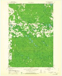
1952 Map of White Lake
USGS Topo · Published 1961About this map
The Menominee Indian Reservation boundary dominates the southern half of this mid-century landscape, marking a clear transition between the forested reservation lands and the developed agricultural and timber tracts to the north. Settlement is concentrated around the village of White Lake and the small community of Elton, where the Chicago and North Western railway facilitated the region's logging economy. The northern reaches are characterized by a dense network of water bodies, including Sawyer Lake and the winding Wolf River, which served as a primary artery through the Nicolet National Forest. Rural infrastructure is well-documented through local landmarks such as Kent Sch, the Kent Lookout Tower, and Sherry Junction, reflecting a period of active land management and small-scale community development before modern consolidation changed the rural schooling and transport patterns of Langlade County.
Find a feature on this map
71 named features on this map. Tap any name to fly to it.
Don’t see what you’re looking for? This feature index may not catch every label — zoom into the map to look around manually.
Map Details
Editions of this 1952 White Lake Map
2 editions found
Other maps of this area

1942 · Elcho
USGS Topo · 1:48,000

1942 · Wabeno
USGS Topo · 1:48,000

1942 · Pearson
USGS Topo · 1:48,000

1950 · Wabeno
USGS Topo · 1:48,000

1950 · Elcho
USGS Topo · 1:48,000

1950 · Lily
USGS Topo · 1:48,000

1951 · Wabeno
USGS Topo · 1:48,000

1952 · Antigo
USGS Topo · 1:48,000

1952 · White Lake
USGS Topo · 1:48,000

1952 · Langlade
USGS Topo · 1:48,000