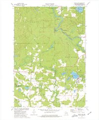
1973 Map of White Lake
USGS Topo · Published 1977About this map
The Wolf River defines this portion of Langlade County, cutting a complex path through the Nicolet National Forest with numerous named rapids such as Oxbow Rapids, Cedar Rapids, and Sherry Rapids. This 1970s survey captures the village of White Lake nestled near the shores of its namesake water body, where local landmarks like the St James Cem and several gravel pits indicate the community's footprint. The landscape is heavily influenced by conservation and timber interests, evidenced by the Wolf River State Fishery Area and the Evergreen River State Fishery Area. An Old Railroad Grade runs east-to-west through the township of Evergreen, marking a former transportation corridor that once connected these timberlands. Further north, the settlement of Hollister sits along the river, surrounded by a network of spring-fed lakes and creeks including Ninemile Creek and Stillhouse Springs.
Find a feature on this map
44 named features on this map. Tap any name to fly to it.
Don’t see what you’re looking for? This feature index may not catch every label — zoom into the map to look around manually.
Map Details
Editions of this 1973 White Lake Map
This is the sole edition of this map. No revisions or reprints were ever made.
Other maps of this area

1942 · Wabeno
USGS Topo · 1:48,000

1942 · Pearson
USGS Topo · 1:48,000

1950 · Wabeno
USGS Topo · 1:48,000

1950 · Lily
USGS Topo · 1:48,000

1951 · Wabeno
USGS Topo · 1:48,000

1952 · White Lake
USGS Topo · 1:48,000

1952 · Langlade
USGS Topo · 1:48,000

1954 · Iron Mountain
USGS Topo · 1:250,000

1959 · Iron Mountain
USGS Topo · 1:250,000
1972 · Reservoir Pond
USGS Topo · 1:24,000