1942 Map of Wabeno
USGS Topo · Published 1942About this map
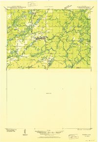
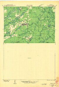
The timber and rail corridors of the Nicolet region are documented in this 1940 field examination, centered on the logging and sawmill hubs of Wabeno and Soperton. The Chicago and Northwestern railroad tracks serve as the primary artery through the landscape, connecting smaller sidings and settlements like Padus, Grant, and Carter. This survey captures the area before the full decline of the old logging railroads, showing several Logging RR spurs still threading through the woods toward the Oconto River. Genealogy researchers will find significant detail in the placement of rural schools like Swan Sch and the Windfall Sch, alongside five distinct burial grounds including Roseland Cem and Lakeview Cem. The northern portion of the map is punctuated by numerous glacial lakes such as Trump Lake and Richardson L, while the presence of an Abandoned CCC Camp and the Indian Community Hall reflects the social and federal footprint on the Forest County landscape during this era.
Find a feature on this map
66 named features on this map. Tap any name to fly to it.
Don’t see what you’re looking for? This feature index may not catch every label — zoom into the map to look around manually.
Map Details
Editions of this 1942 Wabeno Map
This is the sole edition of this map. No revisions or reprints were ever made.
Historical Maps of Laona Through Time
6 maps found