
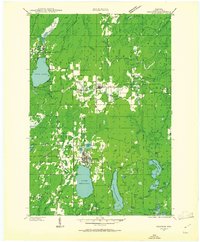
1939 Map of Crandon
USGS Topo · Published 1955About this map
The timber-rich landscape of Nicolet National Forest dominates this pre-war survey, centered on the logging and rail infrastructure of Forest County. At Crandon, the intersection of the Chicago and Northwestern RR and the Minneapolis Sault Ste Marie and Atlantic RR marks a vital hub for the region's industry, with numerous spur lines like the Lumber RR and Fire Lane roads reaching into the backcountry. The map reveals a high density of rural schoolhouses, including Metonga Sch and Range Sch, serving the scattered settlements of Hiles and Argonne. Water is a defining feature of the terrain, from the large expanses of Lake Metonga and Lake Lucerne to the winding course of the Peshtigo River. High vantage points like the Hiles Fire Tower provide a glimpse into the forest management practices of the 1930s.
Find a feature on this map
60 named features on this map. Tap any name to fly to it.
Don’t see what you’re looking for? This feature index may not catch every label — zoom into the map to look around manually.
Map Details
Editions of this 1939 Crandon Map
2 editions found
Other maps of this area

1928 · Three Lakes
USGS Topo · 1:48,000

1938 · Alvin
USGS Topo · 1:48,000

1938 · Three Lakes
USGS Topo · 1:48,000

1939 · Laona
USGS Topo · 1:48,000

1939 · Long Lake
USGS Topo · 1:48,000

1940 · Monico
USGS Topo · 1:48,000

1941 · Crandon
USGS Topo · 1:48,000

1942 · Elcho
USGS Topo · 1:48,000

1942 · Wabeno
USGS Topo · 1:48,000

1942 · Pearson
USGS Topo · 1:48,000