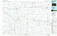
1985 Map of White River
USGS Topo · Published 1986About this map
The White River carves a winding path through the heart of south-central South Dakota, defining a landscape shaped by both hydrology and the steel of the Chicago and North Western railroad. This mid-1980s planimetric survey reveals the tight alignment of settlements along the rail corridor, including Murdo, Okaton, Draper, Vivian, and Presho. These towns serve as central hubs for a vast network of drainage basins, where Medicine Creek and Cottonwood Creek feed into the larger river systems.
Find a feature on this map
91 named features on this map. Tap any name to fly to it.
Don’t see what you’re looking for? This feature index may not catch every label — zoom into the map to look around manually.
Map Details
Editions of this 1985 White River Map
2 editions found
Other maps of this area

1951 · Murdo SE
USGS Topo · 1:24,000

1951 · Badnation
USGS Topo · 1:24,000

1951 · Presho 4 NE
USGS Topo · 1:24,000

1951 · Capa
USGS Topo · 1:24,000

1951 · Stamford SE
USGS Topo · 1:24,000

1951 · Cedar Butte NE
USGS Topo · 1:24,000

1951 · White River NE
USGS Topo · 1:24,000

1951 · Okaton SW
USGS Topo · 1:24,000

1951 · Westover
USGS Topo · 1:24,000

1951 · Badnation NW
USGS Topo · 1:24,000