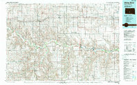
1985 Map of White River
USGS Topo · Published 1988About this map
White River and the Little White River carve intricate, meandering paths through the plains of Mellette, Jones, and Lyman Counties in this mid-1980s landscape. This survey captures a moment of transition where the Chicago Milwaukee St Paul and Pacific railroad tracks run parallel to the modern corridor of Interstate 90, linking the settlements of Murdo, Okaton, Vivian, and Presho. The map reveals a land divided into large-scale administrative townships like Draper, Westover, and Zickrick, illustrating the systematic settlement patterns of the Great Plains.
Find a feature on this map
69 named features on this map. Tap any name to fly to it.
Don’t see what you’re looking for? This feature index may not catch every label — zoom into the map to look around manually.
Map Details
Editions of this 1985 White River Map
2 editions found
Other maps of this area

1951 · Murdo SE
USGS Topo · 1:24,000

1951 · Badnation
USGS Topo · 1:24,000

1951 · Presho 4 NE
USGS Topo · 1:24,000

1951 · Capa
USGS Topo · 1:24,000

1951 · Stamford SE
USGS Topo · 1:24,000

1951 · Cedar Butte NE
USGS Topo · 1:24,000

1951 · White River NE
USGS Topo · 1:24,000

1951 · Okaton SW
USGS Topo · 1:24,000

1951 · Westover
USGS Topo · 1:24,000

1951 · Badnation NW
USGS Topo · 1:24,000