
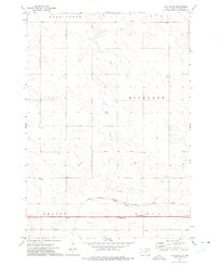
1951 Map of Capa
USGS Topo · Published 1953About this map
The Chicago and North Western railroad corridor defines the northern edge of this West River landscape, tracing the valley of the Bad River as it winds through central South Dakota. Near the small settlement of Capa, the rail line and river establish a vital transportation hub for the surrounding ranching country. The map documents the scattered rural infrastructure of the early 1950s, including Bovine Sch and Hilltop Sch, which served the townships of Bovine, South Creek, and Washington. Local genealogy is anchored by the Catholic Cem and Riverview Cem, while the terrain is marked by prominent landmarks like Flat Top Butte and the winding course of Prairie Dog Creek. The drainage patterns of Dry Creek and its tributaries illustrate the semi-arid character of the region during this post-war period of development in the Missouri River Basin.
Find a feature on this map
13 named features on this map. Tap any name to fly to it.
Don’t see what you’re looking for? This feature index may not catch every label — zoom into the map to look around manually.
Map Details
Editions of this 1951 Capa Map
This is the sole edition of this map. No revisions or reprints were ever made.
Other maps of this area

1951 · Van Metre
USGS Topo · 1:24,000

1951 · Capa NW
USGS Topo · 1:24,000

1951 · Capa SE
USGS Topo · 1:24,000

1954 · Midland SE
USGS Topo · 1:24,000

1954 · Pierre
USGS Topo · 1:250,000

1955 · Martin
USGS Topo · 1:250,000

1958 · Pierre
USGS Topo · 1:250,000

1958 · Martin
USGS Topo · 1:250,000

1972 · Okaton
USGS Topo · 1:24,000
1972 · Okaton NE
USGS Topo · 1:24,000