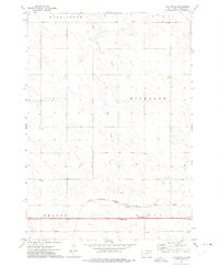
1972 Map of Okaton NE
USGS Topo · Published 1975About this map
The Chicago Milwaukee St Paul and Pacific railroad corridor serves as the primary industrial artery across this section of Jones County, carving through the central townships. Surveyed in the early 1970s, the landscape is defined by vast tracts of open land organized into administrative districts such as Washington, Union, Scovil, and Highland. The natural drainage of the area is led by Ash Draw, which meanders through the northern quadrants toward the rail line. Evidence of modern automotive travel is present near the Okaton and Murdo boundaries, where a highway Rest Area stands as a rare landmark in a region dominated by wide-scale agriculture and transit networks. This survey preserves the spatial relationship between the historic rail path and the evolving prairie townships.
Find a feature on this map
9 named features on this map. Tap any name to fly to it.
Don’t see what you’re looking for? This feature index may not catch every label — zoom into the map to look around manually.
Map Details
Editions of this 1972 Okaton NE Map
This is the sole edition of this map. No revisions or reprints were ever made.
Other maps of this area

1951 · Capa
USGS Topo · 1:24,000

1951 · Okaton SW
USGS Topo · 1:24,000

1951 · Murdo SW
USGS Topo · 1:24,000

1951 · Okaton SE
USGS Topo · 1:24,000

1951 · Capa SE
USGS Topo · 1:24,000

1954 · Pierre
USGS Topo · 1:250,000

1955 · Martin
USGS Topo · 1:250,000

1958 · Pierre
USGS Topo · 1:250,000

1958 · Martin
USGS Topo · 1:250,000

1972 · Murdo
USGS Topo · 1:24,000