
1954 Map of Midland SE
USGS Topo · Published 1966About this map
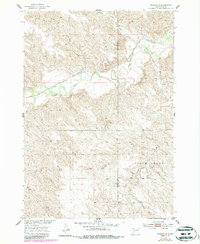
The Chicago and North Western railway cuts through the northern landscape of South Dakota, following the winding valley of the Bad River. This mid-century survey captures the rural infrastructure along the Haakon and Jones county line, where the land is dominated by significant drainage basins like Lone Tree Creek and South Creek. Educational centers for the local ranching community are anchored by the White Bell Sch, a localized landmark in an area otherwise defined by topographical features such as Madsen and Lone Tree. Commercial activity is represented by Gravel Pits located near the rail line, while natural landmarks like Little Prairie Dog Creek and the T M Draw define the erosion patterns of the western prairie. This map reflects the period's focus on the Missouri River Basin development, illustrating the relationship between the rail corridor and the surrounding tributary systems.
Find a feature on this map
12 named features on this map. Tap any name to fly to it.
Don’t see what you’re looking for? This feature index may not catch every label — zoom into the map to look around manually.
Map Details
Editions of this 1954 Midland SE Map
2 editions found
Other maps of this area

1951 · Capa
USGS Topo · 1:24,000

1951 · Capa NW
USGS Topo · 1:24,000

1954 · Midland
USGS Topo · 1:24,000

1954 · Pierre
USGS Topo · 1:250,000

1955 · Martin
USGS Topo · 1:250,000

1958 · Pierre
USGS Topo · 1:250,000

1958 · Martin
USGS Topo · 1:250,000

1972 · Okaton
USGS Topo · 1:24,000

1972 · Stamford NW
USGS Topo · 1:24,000
1972 · Stamford
USGS Topo · 1:24,000