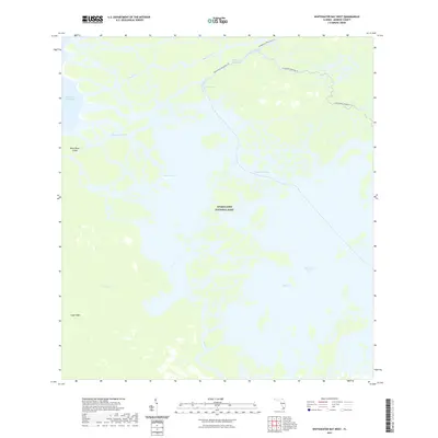
2021 Map of Whitewater Bay West
USGS Topo · Published 2021About this map
Everglades National Park dominates this coastal survey, where a labyrinthine network of tidal channels and mangroves defines the southwestern Florida shoreline. The complex hydrology of the region is evident in the winding courses of the Shark River and Little Shark River, which flow into Oyster Bay and Ponce de Leon Bay. These waters serve as critical conduits for modern exploration, featuring the Wilderness Waterway Trl and the Everglades Paddling Trl, which navigate the intricate passages between Shark River Island and the mainland. To the south, the expanse of Whitewater Bay and Mud Bay illustrates the shallow, brackish environments that characterize the area north of Cape Sable. This map documents a landscape where traditional terrestrial landmarks are replaced by water features like Cormorant Pass and Shark Cutoff, reflecting a wilderness defined entirely by its aquatic connectivity.
Find a feature on this map
16 named features on this map. Tap any name to fly to it.
Don’t see what you’re looking for? This feature index may not catch every label — zoom into the map to look around manually.
Map Details
Editions of this 2021 Whitewater Bay West Map
This is the sole edition of this map. No revisions or reprints were ever made.
Other maps of this area

1956 · Miami
USGS Topo · 1:250,000

1958 · Miami
USGS Topo · 1:250,000

1972 · Whitewater Bay West
USGS Topo · 1:24,000

1972 · Whitewater Bay East
USGS Topo · 1:24,000

1972 · Harney River
USGS Topo · 1:24,000

1972 · Lake Ingraham East
USGS Topo · 1:24,000
1972 · Lake Ingraham West
USGS Topo · 1:24,000

1972 · Tarpon Bay
USGS Topo · 1:24,000

1972 · Shark River Island
USGS Topo · 1:24,000

1972 · Shark Point
USGS Topo · 1:24,000