1967 Map of Whitmore Point SW
USGS Topo · Published 1971About this map
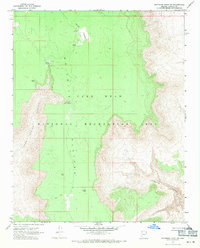
Waring Ranch sits within the high desert landscape of the Shivwits Plateau, surrounded by the protected lands of the Lake Mead National Recreation Area. This 1967 field-checked survey reveals a remote ranching and grazing environment where water is the primary concern for survival and operations. Named catchments and storage points such as Ambush Water Pocket, Spencer Tank, and Peters Pocket are scattered across the terrain, indicating a reliance on seasonal moisture and spring-fed resources.
Find a feature on this map
18 named features on this map. Tap any name to fly to it.
Don’t see what you’re looking for? This feature index may not catch every label — zoom into the map to look around manually.
Map Details
Editions of this 1967 Whitmore Point SW Map
This is the sole edition of this map. No revisions or reprints were ever made.
Other maps of this area

1886 · Diamond Creek
USGS Topo · 1:250,000

1886 · Mt. Trumbull
USGS Topo · 1:250,000

1892 · Diamond Creek
USGS Topo · 1:250,000

1892 · Mt. Trumbull
USGS Topo · 1:250,000

1948 · Williams
USGS Topo · 1:250,000

1953 · Grand Canyon
USGS Topo · 1:250,000

1954 · Williams
USGS Topo · 1:250,000

1956 · Williams
USGS Topo · 1:250,000

1957 · Grand Canyon
USGS Topo · 1:250,000

1958 · Grand Canyon
USGS Topo · 1:250,000