
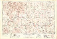
1956 Map of Williams
USGS Topo · Published 1963About this map
The Atchison Topeka and Santa Fe railroad corridor defines the settlement patterns of this mid-century northern Arizona landscape, threading through the high desert and mountain passes. Small rail stops and ranching communities like Hackberry, Valentine, and Peach Springs follow the tracks and the path of Highway 66, which had already become a legendary artery for cross-country travel by this 1956 survey. This alignment skirts the massive Hualapai Indian Reservation and the southern rim of the Lake Mead National Recreation Area, where the Colorado River carves through the western plateau.
Find a feature on this map
44 named features on this map. Tap any name to fly to it.
Don’t see what you’re looking for? This feature index may not catch every label — zoom into the map to look around manually.
Map Details
Editions of this 1956 Williams Map
3 editions found
Other maps of this area

1886 · Diamond Creek
USGS Topo · 1:250,000

1886 · Camp Mohave
USGS Topo · 1:250,000

1886 · Saint Thomas
USGS Topo · 1:250,000

1886 · San Francisco Mtns
USGS Topo · 1:250,000

1886 · Mt. Trumbull
USGS Topo · 1:250,000

1886 · Chino
USGS Topo · 1:250,000

1886 · Echo Cliffs
USGS Topo · 1:250,000

1886 · Kaibab
USGS Topo · 1:250,000

1887 · Verde
USGS Topo · 1:250,000

1887 · Prescott
USGS Topo · 1:250,000