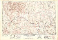
1956 Map of Williams
USGS Topo · Published 1963About this map
The Grand Canyon National Park and the vast Hualapai Indian Reservation dominate this landscape, revealing a period of significant federal land management across northern Arizona. The Atchison Topeka and Santa Fe railroad serves as the primary corridor for commerce and travel, connecting historic whistle-stops and mountain towns. Industry is visible through specialized operations like the Music Mountain Mine and Kehl Mine, while the southern reaches show the early agricultural and ranching layout of the Chino Valley.
Find a feature on this map
88 named features on this map. Tap any name to fly to it.
Don’t see what you’re looking for? This feature index may not catch every label — zoom into the map to look around manually.
Map Details
Editions of this 1956 Williams Map
3 editions found

Other maps of this area

1886 · Diamond Creek
USGS Topo · 1:250,000

1886 · Camp Mohave
USGS Topo · 1:250,000

1886 · Saint Thomas
USGS Topo · 1:250,000

1886 · San Francisco Mtns
USGS Topo · 1:250,000

1886 · Mt. Trumbull
USGS Topo · 1:250,000

1886 · Chino
USGS Topo · 1:250,000

1886 · Echo Cliffs
USGS Topo · 1:250,000

1886 · Kaibab
USGS Topo · 1:250,000

1887 · Verde
USGS Topo · 1:250,000

1887 · Prescott
USGS Topo · 1:250,000