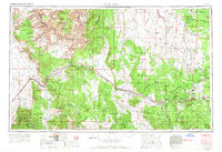
1956 Map of Williams
USGS Topo · Published 1966About this map
The Atchison Topeka and Santa Fe railroad serves as the primary corridor for human activity across this 1950s Arizona landscape, connecting desert outposts with the high timber country. Moving west to east, the tracks and highway 66 thread through the Hualapai Valley and the Hualapai Indian Reservation, passing through the ranching and rail settlements of Peach Springs, Truxton, and Valentine. This infrastructure circumvents the massive geological barriers of the Aubrey Cliffs and the Grand Wash Cliffs, providing a vital link between the Lake Mead region and the burgeoning communities of Ash Fork and Williams.
Find a feature on this map
40 named features on this map. Tap any name to fly to it.
Don’t see what you’re looking for? This feature index may not catch every label — zoom into the map to look around manually.
Map Details
Editions of this 1956 Williams Map
3 editions found

Other maps of this area

1886 · Diamond Creek
USGS Topo · 1:250,000

1886 · Camp Mohave
USGS Topo · 1:250,000

1886 · Saint Thomas
USGS Topo · 1:250,000

1886 · San Francisco Mtns
USGS Topo · 1:250,000

1886 · Mt. Trumbull
USGS Topo · 1:250,000

1886 · Chino
USGS Topo · 1:250,000

1886 · Echo Cliffs
USGS Topo · 1:250,000

1886 · Kaibab
USGS Topo · 1:250,000

1887 · Verde
USGS Topo · 1:250,000

1887 · Prescott
USGS Topo · 1:250,000