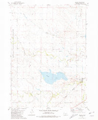
1980 Map of Whitney
USGS Topo · Published 1981About this map
Whitney anchors the southeastern corner of this Dawes County landscape, situated where the Chicago and North Western railroad parallels the winding path of the White River. The village is served by the nearby Whitney Cem, while the surrounding prairie is defined by an extensive water management system. Dominating the central terrain is Whitney Lake, supported by a network of infrastructure including a prominent Aqueduct and a Siphon that facilitate movement across the drainage basins.
Find a feature on this map
20 named features on this map. Tap any name to fly to it.
Don’t see what you’re looking for? This feature index may not catch every label — zoom into the map to look around manually.
Map Details
Editions of this 1980 Whitney Map
This is the sole edition of this map. No revisions or reprints were ever made.
Other maps of this area

1955 · Alliance
USGS Topo · 1:250,000

1957 · Alliance
USGS Topo · 1:250,000

1958 · Alliance
USGS Topo · 1:250,000

1980 · Horn
USGS Topo · 1:24,000

1980 · Crow Butte
USGS Topo · 1:24,000

1980 · Wolf Butte
USGS Topo · 1:24,000

1980 · Lone Tree Ranch
USGS Topo · 1:24,000

1980 · Wayside
USGS Topo · 1:24,000
1980 · Trunk Butte
USGS Topo · 1:24,000
1980 · Chimney Butte
USGS Topo · 1:24,000