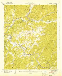
1941 Map of Whittier
USGS Topo · Published 1941About this map
Cherokee Indian Reservation lands dominate this 1941 landscape, where the Oconaluftee River meets the Tuckasegee River. The area shows a complex intersection of tribal heritage and federal land management, with the Qualla Tract and the Great Smoky Mts National Park border both present. Settlements like Cherokee and Whittier are hubs of activity, the latter situated along the Southern railroad line. Local life is documented through numerous mountain houses of worship, including Worley Chapel and Gargie Memorial Ch.
Find a feature on this map
79 named features on this map. Tap any name to fly to it.
Don’t see what you’re looking for? This feature index may not catch every label — zoom into the map to look around manually.
Map Details
Editions of this 1941 Whittier Map
2 editions found
Other maps of this area

1891 · Cowee
USGS Topo · 1:125,000

1893 · Mt Guyot
USGS Topo · 1:125,000

1897 · Cowee
USGS Topo · 1:125,000

1907 · Cowee
USGS Topo · 1:125,000

1912 · Mt Guyot
USGS Topo · 1:125,000

1933 · Bryson
USGS Topo · 1:62,500

1935 · Cullowhee
USGS Topo · 1:24,000

1935 · Addie
USGS Topo · 1:24,000

1936 · Greens Creek
USGS Topo · 1:24,000

1936 · Bunches Bald
USGS Topo · 1:24,000
Featured Places
- Cherokee, Yellowhill Community
- Birdtown Community, NC
- Whittier, NC
- Painttown Community, NC
- Wolftown Community, NC