
1936 Map of Bunches Bald
USGS Topo · Published 1936About this map
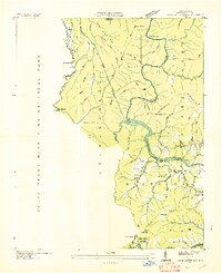
Cherokee Indian Reservation lands dominate the southern half of this 1936 survey, showing the complex intersection of federal forest and park boundaries in the North Carolina high country. The map documents the region during the early development of the Great Smoky Mountains National Park, where the State National Boundary cuts through the ridges. Fire prevention infrastructure is prominent, featuring a Lookout Tower on Barnett Knob and a second Lookout Tower positioned near the Jackson Haywood Co Boundary. Local community life is represented by the Peach Tree Ch near the banks of Jonathan Creek and the Peach Tree Ch Creek. The terrain is characterized by a network of drainage systems like Raven Fk and Bunches Creek, connected by early routes such as the Bunches Trail through Bunches Gap.
Find a feature on this map
47 named features on this map. Tap any name to fly to it.
Don’t see what you’re looking for? This feature index may not catch every label — zoom into the map to look around manually.
Map Details
Editions of this 1936 Bunches Bald Map
This is the sole edition of this map. No revisions or reprints were ever made.
Other maps of this area

1891 · Cowee
USGS Topo · 1:125,000

1893 · Mt Guyot
USGS Topo · 1:125,000

1897 · Cowee
USGS Topo · 1:125,000

1907 · Cowee
USGS Topo · 1:125,000

1912 · Mt Guyot
USGS Topo · 1:125,000

1933 · Bryson
USGS Topo · 1:62,500

1935 · Dellwood
USGS Topo · 1:24,000

1935 · Hazelwood
USGS Topo · 1:24,000

1935 · Addie
USGS Topo · 1:24,000
1936 · Cove Creek Gap
USGS Topo · 1:24,000