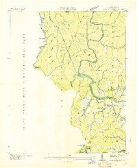
1936 Map of Cove Creek Gap
USGS Topo · Published 1936About this map
Waterville Lake and the winding Pigeon River dominate this 1936 landscape, where the Tennessee Valley Authority was actively shaping the region's infrastructure. The map reveals a mountain economy transitioning toward electrification, evidenced by the prominent hydro-electric power transmission lines cutting across Cataloochee Mountain and White Oak Mountain. These utility corridors run alongside traditional settlements and family landmarks such as Shelton Laurel and Chestnut Flats.
Find a feature on this map
64 named features on this map. Tap any name to fly to it.
Don’t see what you’re looking for? This feature index may not catch every label — zoom into the map to look around manually.
Map Details
Editions of this 1936 Cove Creek Gap Map
This is the sole edition of this map. No revisions or reprints were ever made.
Other maps of this area

1893 · Mt Guyot
USGS Topo · 1:125,000

1894 · Asheville
USGS Topo · 1:125,000

1901 · Asheville
USGS Topo · 1:125,000

1912 · Mt Guyot
USGS Topo · 1:125,000

1935 · Newport
USGS Topo · 1:48,000

1935 · Hartford
USGS Topo · 1:24,000

1935 · Dellwood
USGS Topo · 1:24,000

1935 · Clyde
USGS Topo · 1:24,000

1935 · Lemon Gap
USGS Topo · 1:24,000

1936 · Bunches Bald
USGS Topo · 1:24,000