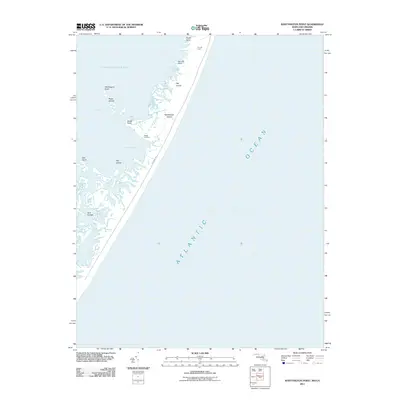
2011 Map of Whittington Point
USGS Topo · Published 2011About this map
Assateague Island dominates this coastal landscape, serving as a narrow barrier between the open Atlantic Ocean and the sheltered waters of Chincoteague Bay. Along the bay-side shoreline, the complex geography of the marshland is punctuated by landforms such as Fox Hill Point and Whittington Point, with low-lying areas like Big Levels and Fox Hill Level indicating the island's tidal character. Human activity is largely concentrated at Scotts Landing, while the interior of the island is traversed by Bayberry Dr. The map provides a detailed view of the various smaller landmasses and inlets that define this reach of the Delmarva Peninsula, including the Pirate Islands, Twin Islands, and the secluded Lone Pond. Small tidal passages like Green Bay Run illustrate the constant movement of water through this sensitive estuarine environment.
Find a feature on this map
18 named features on this map. Tap any name to fly to it.
Don’t see what you’re looking for? This feature index may not catch every label — zoom into the map to look around manually.
Map Details
Editions of this 2011 Whittington Point Map
This is the sole edition of this map. No revisions or reprints were ever made.
Other maps of this area

1901 · Snow Hill
USGS Topo · 1:62,500

1901 · Green Run
USGS Topo · 1:62,500

1938 · Green Run
USGS Topo · 1:62,500

1942 · Chincoteague East
USGS Topo · 1:24,000

1942 · Tingles Island
USGS Topo · 1:24,000

1942 · Wesley
USGS Topo · 1:24,000

1943 · Boxiron
USGS Topo · 1:31,680

1943 · Whittington Point
USGS Topo · 1:31,680
1943 · Wesley
USGS Topo · 1:31,680
1943 · Chincoteague East
USGS Topo · 1:31,680