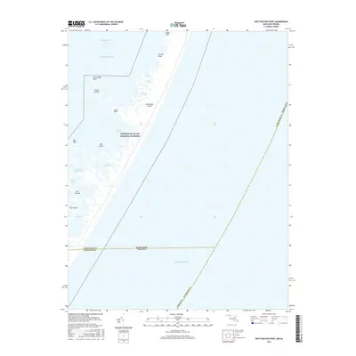
2016 Map of Whittington Point
USGS Topo · Published 2016About this map
Assateague Island National Seashore dominates this coastal landscape, capturing the shifting barrier island environment along the Atlantic Ocean. The topography is defined by the intricate salt marshes and tidal waterways of Chincoteague Bay, where land and water blur into a complex of islands and points. Notable terrestrial features include Whittington Point, Scotts Point, and the Pirate Islands, which sit among vast wetlands like Rum Harbor Marsh. This survey documents the precise state-line boundary between Worcester County, Maryland and Accomack County, Virginia as it bisects the marshes and open waters. The map reveals the isolation of interior island waters such as Lone Pond and Bounder Pond, providing a detailed record of the shoreline before modern climate and storm-driven erosion further alter these sensitive Delmarva habitats.
Find a feature on this map
25 named features on this map. Tap any name to fly to it.
Don’t see what you’re looking for? This feature index may not catch every label — zoom into the map to look around manually.
Map Details
Editions of this 2016 Whittington Point Map
This is the sole edition of this map. No revisions or reprints were ever made.
Other maps of this area

1901 · Snow Hill
USGS Topo · 1:62,500

1901 · Green Run
USGS Topo · 1:62,500

1938 · Green Run
USGS Topo · 1:62,500

1942 · Chincoteague East
USGS Topo · 1:24,000

1942 · Tingles Island
USGS Topo · 1:24,000

1942 · Wesley
USGS Topo · 1:24,000

1943 · Boxiron
USGS Topo · 1:31,680

1943 · Whittington Point
USGS Topo · 1:31,680
1943 · Wesley
USGS Topo · 1:31,680
1943 · Chincoteague East
USGS Topo · 1:31,680