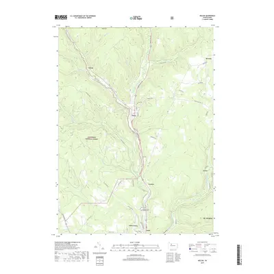
2019 Map of Wilcox
USGS Topo · Published 2019About this map
Wilcox sits at the junction of the West Branch Clarion River and several tributary runs in this portion of the Pennsylvania highlands. This area of Elk County is defined by the deep valleys and high ridges within the Allegheny National Forest, where a network of forestry roads and state routes connects small rural settlements like Dahoga, Tambine, and Rasselas. The topography dictated the layout of the region's early infrastructure, with the Johnsonburg railroad following the watercourses south toward the paper mill town of the same name. Local heritage is preserved at the Wilcox Cem and Wardvale United Methodist Cem, situated along the winding paths of Clarion Rd and Old State Rd. The map details the complex drainage system of the W Br Clarion River, illustrating how the timber and water resources of the forest shaped the development of these tight-knit mountain communities.
Find a feature on this map
64 named features on this map. Tap any name to fly to it.
Don’t see what you’re looking for? This feature index may not catch every label — zoom into the map to look around manually.
Map Details
Editions of this 2019 Wilcox Map
This is the sole edition of this map. No revisions or reprints were ever made.
Other maps of this area

1934 · Kane
USGS Topo · 1:48,000

1935 · Mt. Jewett
USGS Topo · 1:48,000

1939 · Kane
USGS Topo · 1:62,500

1940 · Hallton
USGS Topo · 1:48,000

1940 · Mt. Jewett
USGS Topo · 1:62,500

1941 · Ridgway
USGS Topo · 1:62,500

1943 · Hallton
USGS Topo · 1:62,500

1944 · Ridgway
USGS Topo · 1:62,500

1957 · Warren
USGS Topo · 1:250,000

1958 · Warren
USGS Topo · 1:250,000
Featured Places
- Saint Marys, PA
- Wilcox, Jones Township
- Dahoga, Jones Township
- Tambine, Jones Township
- Ketner, Jones Township