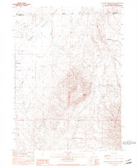
1990 Map of Wilder Creek Ranch
USGS Topo · Published 1990About this map
Wilder Creek Ranch serves as a lone outpost in the high desert where the Bilk Creek Mountains meet the sweeping Pueblo Valley. This 1990 provisional study documents a remote ranching landscape defined by scattered water sources like Mud Spring, Stock Pond, and Wilder Ranch Well. The mapping illustrates the stark transition from the arid Pueblo Flat and its Sand Dunes to the sharp elevation of Lone Mountain. At Denio Junction, the intersection of transport and geography is clear where the state line divides Harney and Humboldt counties. Numerous labels for Prospects throughout the southern hills suggest the area's legacy of mineral exploration, while the presence of a Flowing Well and irrigation features points to the ongoing efforts to manage water in this Great Basin environment.
Find a feature on this map
24 named features on this map. Tap any name to fly to it.
Don’t see what you’re looking for? This feature index may not catch every label — zoom into the map to look around manually.
Map Details
Editions of this 1990 Wilder Creek Ranch Map
This is the sole edition of this map. No revisions or reprints were ever made.
Other maps of this area

1886 · Disaster
USGS Topo · 1:250,000

1893 · Disaster
USGS Topo · 1:250,000

1954 · Vya
USGS Topo · 1:250,000

1955 · Adel
USGS Topo · 1:250,000

1957 · Adel
USGS Topo · 1:250,000

1958 · Vya
USGS Topo · 1:250,000

1958 · Adel
USGS Topo · 1:250,000

1961 · Trident Peak
USGS Topo · 1:62,500

1962 · Vya
USGS Topo · 1:250,000

1962 · Adel
USGS Topo · 1:250,000