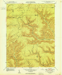
1950 Map of Wildwood Fire Tower
USGS Topo · Published 1950About this map
The Wildwood Fire Tower stands as a prominent lookout over a complex network of deep hollows and creek branches where the borders of Elk, McKean, and Cameron counties converge. This 1950 survey reveals a landscape shaped by narrow-gauge drainage and small settlements like Wellendorf Station and Straight Creek. The topography is defined by intricately named drainages such as Dead Mans Lick, Indian Camp Run, and Billy Buck Run, suggesting a history of hunting and early backcountry exploration. These names, along with family-linked landmarks like Al Wright Hol and Bingman Hol, provide a detailed record of the local geography before major modern development. The presence of Boy Scout Hollow and numerous hollows like Naval Hollow and Devils Hole reflects a terrain where timbering and local recreation likely dictated the naming of every fold in the hills. Waterways like Driftwood Branch and Clear Creek weave through the townships of Sergeant, Shippen, and Jones, anchoring the region's physical identity.
Find a feature on this map
47 named features on this map. Tap any name to fly to it.
Don’t see what you’re looking for? This feature index may not catch every label — zoom into the map to look around manually.
Map Details
Editions of this 1950 Wildwood Fire Tower Map
2 editions found
Other maps of this area

1935 · Mt. Jewett
USGS Topo · 1:48,000

1940 · Mt. Jewett
USGS Topo · 1:62,500

1941 · Benezette
USGS Topo · 1:62,500

1941 · Ridgway
USGS Topo · 1:62,500

1943 · Benezette
USGS Topo · 1:62,500

1944 · Ridgway
USGS Topo · 1:62,500

1948 · Crosby
USGS Topo · 1:62,500

1948 · Wildwood Fire Tower
USGS Topo · 1:24,000

1948 · Rich Valley
USGS Topo · 1:24,000

1948 · Norwich
USGS Topo · 1:24,000