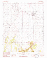
1986 Map of Willard
USGS Topo · Published 1986About this map
The high plains of Torrance County meet the northern edges of the Mesa de los Jumanos in this mid-1980s survey. At the center of the local transport network, the town of Willard serves as a junction point where the Atchison Topeka and Santa Fe Railway cuts across the basin. The landscape is a mix of industrial infrastructure and stark geographical features, with a prominent Pipeline and Transmission Line following the rail corridor, while an Old R.R. Grade suggests the evolution of regional transit. To the south, the terrain rises sharply toward Jumanos Knob and James, providing a dramatic contrast to the northern flats. Local history is etched into the land through features like the Cem northeast of town and several Gravel Pits, while drainage patterns like Chavez Draw and Dead Dog Canyon define the watershed descending from the mesa.
Find a feature on this map
18 named features on this map. Tap any name to fly to it.
Don’t see what you’re looking for? This feature index may not catch every label — zoom into the map to look around manually.
Map Details
Editions of this 1986 Willard Map
This is the sole edition of this map. No revisions or reprints were ever made.
Other maps of this area

1917 · Estancia
USGS Topo · 1:125,000

1954 · Fort Sumner
USGS Topo · 1:250,000

1954 · Socorro
USGS Topo · 1:250,000

1956 · Mountainair
USGS Topo · 1:62,500

1958 · Socorro
USGS Topo · 1:250,000

1958 · Fort Sumner
USGS Topo · 1:250,000

1962 · Socorro
USGS Topo · 1:250,000
1972 · Mesa Draw
USGS Topo · 1:24,000
1972 · Round Top
USGS Topo · 1:24,000

1978 · Laguna Del Perro North
USGS Topo · 1:24,000