
1947 Map of Williamstown
USGS Topo · Published 1947About this map
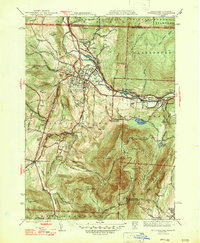
Williams College anchors the northern portion of this 1947 survey, where the Hoosic River winds past the academic grounds and Weston Field. The landscape is a study in verticality, dominated by the massive presence of Mt Greylock to the south, featuring the War Memorial Beacon and the high passage of the Appalachian Trail. To the east, the industrial character of North Adams begins to emerge through settlements like Blackinton and Braytonville along the Boston and Maine Railroad corridor.
Find a feature on this map
73 named features on this map. Tap any name to fly to it.
Don’t see what you’re looking for? This feature index may not catch every label — zoom into the map to look around manually.
Map Details
Editions of this 1947 Williamstown Map
2 editions found
Other maps of this area

1886 · Greylock
USGS Topo · 1:62,500

1888 · Berlin
USGS Topo · 1:62,500

1890 · Berlin
USGS Topo · 1:62,500

1891 · Greylock
USGS Topo · 1:62,500

1893 · Greylock
USGS Topo · 1:62,500

1894 · Berlin
USGS Topo · 1:62,500

1897 · Hoosick
USGS Topo · 1:62,500

1898 · Berlin
USGS Topo · 1:62,500

1898 · Bennington
USGS Topo · 1:62,500

1898 · Greylock
USGS Topo · 1:62,500