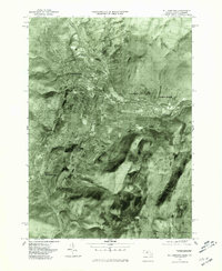
1975 Map of Williamstown
USGS Topo · Published 1981About this map
The Hoosic River valley serves as the central corridor for this mid-1970s orthophotograph, showcasing the industrial and academic landscape of Northern Berkshire County. The imagery reveals the developed core of Williamstown and its satellite settlements, including the distinct residential and industrial patterns of Blackinton and White Oaks. The terrain is dominated by the massive rise of Mt Greylock to the south, which dictates the layout of the region's transport and water networks.
Find a feature on this map
10 named features on this map. Tap any name to fly to it.
Don’t see what you’re looking for? This feature index may not catch every label — zoom into the map to look around manually.
Map Details
Editions of this 1975 Williamstown Map
This is the sole edition of this map. No revisions or reprints were ever made.
Other maps of this area

1886 · Greylock
USGS Topo · 1:62,500

1888 · Berlin
USGS Topo · 1:62,500

1890 · Berlin
USGS Topo · 1:62,500

1891 · Greylock
USGS Topo · 1:62,500

1893 · Greylock
USGS Topo · 1:62,500

1894 · Berlin
USGS Topo · 1:62,500

1897 · Hoosick
USGS Topo · 1:62,500

1898 · Berlin
USGS Topo · 1:62,500

1898 · Bennington
USGS Topo · 1:62,500

1898 · Greylock
USGS Topo · 1:62,500