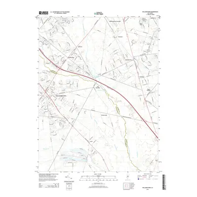
2014 Map of Williamstown
USGS Topo · Published 2014About this map
Williamstown sits at the heart of this 2014 survey, where the expanding suburban landscape of New Jersey meets the intricate drainage network of the Pinelands. The geography is defined by the Great Egg Harbor River and its numerous tributaries, including Ducks Nest Stream, Squankum Br, and Hospitality Br. These waterways feed several significant impoundments such as New Brooklyn Lake and Victory Lakes. The map reveals a dense network of residential development in Sicklerville and Andrews, contrasted by the more dispersed settlements of Cecil and Broad Lane. Local historical markers like the Hopewell Cem near Florence and the uniquely named Seven Causeways provide points of interest for genealogists and local historians tracing the evolution of these Camden and Gloucester County communities. The crossing of the Atlantic City Expressway through the Fourmile Branch basin highlights the modern transport infrastructure overlaying this older coastal plain hydrology.
Find a feature on this map
223 named features on this map. Tap any name to fly to it.
Don’t see what you’re looking for? This feature index may not catch every label — zoom into the map to look around manually.
Map Details
Editions of this 2014 Williamstown Map
This is the sole edition of this map. No revisions or reprints were ever made.
Other maps of this area

1888 · Mount Holly
USGS Topo · 1:62,500

1890 · Hammonton
USGS Topo · 1:62,500

1890 · Glassboro
USGS Topo · 1:62,500

1891 · Philadelphia
USGS Topo · 1:62,500

1894 · Hammonton
USGS Topo · 1:62,500

1894 · Mount Holly
USGS Topo · 1:62,500

1894 · Philadelphia
USGS Topo · 1:62,500

1896 · Philadelphia
USGS Topo · 1:62,500

1898 · Glassboro
USGS Topo · 1:62,500

1898 · Philadelphia
USGS Topo · 1:62,500
Featured Places
- Sicklerville, Winslow Township
- Winslow Township, NJ
- Monroe Township, NJ
- Williamstown, Monroe Township
- Chesilhurst, NJ