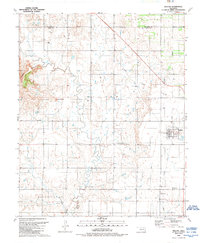
1989 Map of Willow
USGS Topo · Published 1989About this map
Willow and Brinkman serve as the primary hubs in this Greer County landscape, captured during a period of active resource extraction. The area is defined by the Bloomington Oil and Gas Field to the south and another extensive Gas Field in the center-east, with numerous Gas Wells dotting the terrain. The northern boundary is marked by the North Fork of the Red River, while the western side is dominated by the elevations of Haystack Mountain and The Haystack. This map provides significant genealogical value through the documentation of the Willow Cem and Brinkman Cem. The drainage of Haystack Creek carves a path through the center of the sheet, illustrating the transition from the river lowlands to the higher, gas-rich plains. Settlement patterns follow the established road networks, connecting the smaller community of Moravia to the larger town centers.
Find a feature on this map
15 named features on this map. Tap any name to fly to it.
Don’t see what you’re looking for? This feature index may not catch every label — zoom into the map to look around manually.
Map Details
Editions of this 1989 Willow Map
This is the sole edition of this map. No revisions or reprints were ever made.
Other maps of this area

1955 · Lawton
USGS Topo · 1:250,000

1955 · Clinton
USGS Topo · 1:250,000

1957 · Clinton
USGS Topo · 1:250,000

1961 · Willow
USGS Topo · 1:62,500

1961 · Retrop
USGS Topo · 1:62,500

1971 · Mangum North
USGS Topo · 1:24,000

1971 · Granite
USGS Topo · 1:24,000

1971 · Reed
USGS Topo · 1:24,000

1985 · Elk City
USGS Topo · 1:100,000

1985 · Altus
USGS Topo · 1:100,000