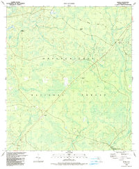
1990 Map of Wilma
USGS Topo · Published 1990About this map
The Apalachicola National Forest dominates this landscape, showing a dense network of hydrologic features and forest management roads at the start of the 1990s. The terrain is characterized by numerous cypress bays and swamps, including Fullman Hill Bay, Whitehead Swamp, and the evocative Devils Old Field Swamp. These wetlands feed into the New River and its various tributaries like South Creek and Hogpen Creek. Small named locales such as Wilma, Vilas, and Central City are situated along the primary transportation corridors, providing a look at the scattered settlement pattern within the federal forest lands.
Find a feature on this map
37 named features on this map. Tap any name to fly to it.
Don’t see what you’re looking for? This feature index may not catch every label — zoom into the map to look around manually.
Map Details
Editions of this 1990 Wilma Map
This is the sole edition of this map. No revisions or reprints were ever made.
Other maps of this area

1944 · Queens Bay
USGS Topo · 1:24,000

1945 · Kennedy Creek
USGS Topo · 1:31,680

1945 · Estiffanulga
USGS Topo · 1:31,680

1945 · Orange
USGS Topo · 1:31,680

1945 · Woods
USGS Topo · 1:31,680

1945 · Telogia
USGS Topo · 1:24,000

1946 · Queens Bay
USGS Topo · 1:31,680

1946 · Sumatra
USGS Topo · 1:31,680

1946 · Telogia
USGS Topo · 1:31,680

1946 · Owens Bridge
USGS Topo · 1:31,680