1984 Map of Wilmington
USGS Topo · Published 1988About this map
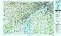
The Delaware River serves as the central artery for this 1984 survey, anchoring a complex interstate corridor where Delaware, New Jersey, Pennsylvania, and Maryland converge. The landscape is defined by the heavy infrastructure of the late 20th century, including the New Jersey Turnpike and major rail lines operated by Conrail and Amtrak. While urban centers like Wilmington and Camden show dense development, the map also captures significant protected lands such as Elk Neck State Forest and the White Clay Creek State Preserve.
Find a feature on this map
179 named features on this map. Tap any name to fly to it.
Don’t see what you’re looking for? This feature index may not catch every label — zoom into the map to look around manually.
Map Details
Editions of this 1984 Wilmington Map
2 editions found

Other maps of this area

1888 · Mount Holly
USGS Topo · 1:62,500

1890 · Hammonton
USGS Topo · 1:62,500

1890 · Salem
USGS Topo · 1:62,500

1890 · Tuckahoe
USGS Topo · 1:62,500

1890 · Bay Side
USGS Topo · 1:62,500

1890 · Bridgeton
USGS Topo · 1:62,500

1890 · Burlington
USGS Topo · 1:62,500

1890 · Glassboro
USGS Topo · 1:62,500

1891 · Philadelphia
USGS Topo · 1:62,500

1893 · Germantown
USGS Topo · 1:62,500