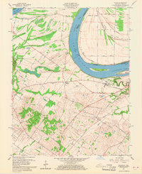
1959 Map of Wilson
USGS Topo · Published 1969About this map
The Ohio River dominates this landscape, serving as the border between Kentucky and Indiana where the low waterline was established by U.S. Corps of Engineers surveys from 1912-1913. The river's influence is evident in the intricate network of wetlands and seasonal watercourses like Little Cypress Slough and Big Swan Pond that define the northern floodplain. Infrastructure of the mid-20th century is well-documented, featuring Lock and Dam No 48 and the nearby Henderson Airport south of Geneva. The southern portion transitions into more elevated terrain at Sugar Tree Ridge and Hickory Ridge. Local history is preserved through the mapping of rural landmarks such as St Johns Ch and several family-named burial grounds, including the Stroud Cem and Corydon Cem, providing a detailed look at the settlement patterns around the communities of Geneva and Wilson.
Find a feature on this map
54 named features on this map. Tap any name to fly to it.
Don’t see what you’re looking for? This feature index may not catch every label — zoom into the map to look around manually.
Map Details
Editions of this 1959 Wilson Map
2 editions found
Other maps of this area

1906 · Sebree
USGS Topo · 1:62,500

1907 · Morganfield
USGS Topo · 1:62,500

1914 · Henderson
USGS Topo · 1:48,000

1916 · Henderson
USGS Topo · 1:62,500

1917 · Uniontown
USGS Topo · 1:62,500

1949 · Poole
USGS Topo · 1:24,000

1949 · Robards
USGS Topo · 1:24,000

1951 · Poole
USGS Topo · 1:24,000

1951 · Waverly
USGS Topo · 1:24,000

1951 · Robards
USGS Topo · 1:24,000