1973 Map of Windsor
USGS Topo · Published 1975About this map
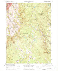
Adams and the winding Hoosic River anchor the northwest corner of this map, where the industrial and residential footprint of the town meets the rising slopes of the Berkshires. The landscape is defined by massive public land holdings, including the Savoy Mountain State Forest and the Windsor State Forest, which preserve vast stretches of terrain around peaks like Borden Mtn and Lewis Hill. The Penn Central rail line follows the river corridor, supporting the region's transport network near established institutions like Hoosac Valley High Sch and St Stanislaus Ch.
Find a feature on this map
79 named features on this map. Tap any name to fly to it.
Don’t see what you’re looking for? This feature index may not catch every label — zoom into the map to look around manually.
Map Details
Editions of this 1973 Windsor Map
2 editions found

Other maps of this area

1886 · Greylock
USGS Topo · 1:62,500

1886 · Hawley
USGS Topo · 1:62,500

1886 · Chesterfield
USGS Topo · 1:62,500

1886 · Becket
USGS Topo · 1:62,500

1888 · Becket
USGS Topo · 1:62,500

1888 · Chesterfield
USGS Topo · 1:62,500

1890 · Hawley
USGS Topo · 1:62,500

1891 · Greylock
USGS Topo · 1:62,500

1893 · Chesterfield
USGS Topo · 1:62,500

1893 · Becket
USGS Topo · 1:62,500