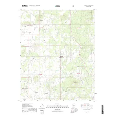
2018 Map of Wing Mountain
USGS Topo · Published 2018About this map
Wing Mtn and the Hochderffer Hills anchor this high-elevation landscape within the Coconino National Forest and Kaibab National Forest. The map documents a critical intersection of historical transportation and modern utility, where the path of Old Rte "66" skirts the southern edge near Brannigan Flat. This area is defined by its volcanic geology and water management, visible through the numerous cinder cones like Wild Bill Hill and a dense network of earthen tanks such as Dent Tank and Sayre Tank used for livestock. The eastern portion includes the edge of Fort Valley and a series of winter-designated routes, including Wing Mountain (Snow) and Pipeline #3 (Snow), reflecting the region's seasonal usage. This survey captures the transition from open grazing land at Government Prairie to the timbered slopes of the San Francisco Volcanic Field.
Find a feature on this map
74 named features on this map. Tap any name to fly to it.
Don’t see what you’re looking for? This feature index may not catch every label — zoom into the map to look around manually.
Map Details
Editions of this 2018 Wing Mountain Map
This is the sole edition of this map. No revisions or reprints were ever made.
Other maps of this area

1886 · San Francisco Mtns
USGS Topo · 1:250,000

1891 · San Francisco Mtns
USGS Topo · 1:250,000

1894 · San Francisco Mtns
USGS Topo · 1:250,000

1899 · San Francisco Mtns
USGS Topo · 1:250,000

1908 · Flagstaff
USGS Topo · 1:125,000

1912 · Flagstaff
USGS Topo · 1:125,000

1947 · Flagstaff
USGS Topo · 1:250,000

1954 · Flagstaff
USGS Topo · 1:250,000

1958 · Flagstaff
USGS Topo · 1:250,000

1960 · Flagstaff
USGS Topo · 1:250,000