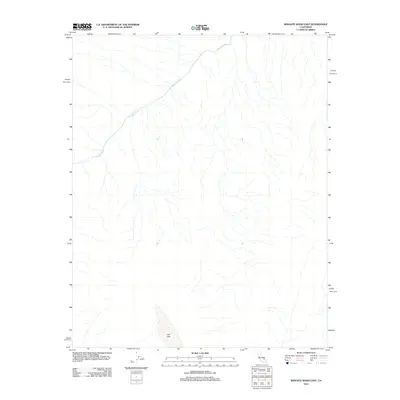
2012 Map of Wingate Wash East
USGS Topo · Published 2012About this map
Wingate Wash defines the drainage patterns of this arid San Bernardino County landscape as it appeared in 2012. This USGS survey highlights the ephemeral nature of water in the California desert, tracing the intricate network of dry washes that converge and flow toward the north and west. Near the southern edge of the quadrangle, the dry bed of Lost Lake serves as a significant topographic basin, illustrating the endorheic drainage characteristic of this region. The absence of roads, buildings, or human-made infrastructure across the entire sheet underscores the isolation of this corner of the Mojave Desert. Researchers of geomorphology will find the fine-grained contour work useful for studying alluvial fan development and the natural erosion patterns of this desert valley.
Find a feature on this map
2 named features on this map. Tap any name to fly to it.
Don’t see what you’re looking for? This feature index may not catch every label — zoom into the map to look around manually.
Map Details
Editions of this 2012 Wingate Wash East Map
This is the sole edition of this map. No revisions or reprints were ever made.
Other maps of this area

1933 · Avawatz Mountains
USGS Topo · 1:250,000

1947 · Trona
USGS Topo · 1:250,000

1948 · Trona
USGS Topo · 1:250,000

1948 · Quail Mountains
USGS Topo · 1:62,500

1948 · Leach Lake
USGS Topo · 1:62,500

1950 · Wingate Wash
USGS Topo · 1:62,500

1950 · Confidence Hills
USGS Topo · 1:62,500

1951 · Quail Mountains
USGS Topo · 1:62,500
1951 · Leach Lake
USGS Topo · 1:62,500

1953 · Trona
USGS Topo · 1:250,000