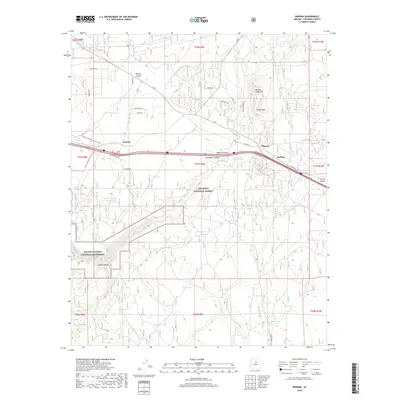
2018 Map of Winona
USGS Topo · Published 2018About this map
Winona and the surrounding high-desert landscape of Coconino County are defined here by a network of seasonal watercourses and volcanic landforms. The eastern reaches of Walnut Canyon National Monument extend into the southwestern portion of the sheet, where Walnut Creek carves through deep limestone layers. North of the Interstate, the Darling Cinder Pit and Cinder Mountain reflect the region's volcanic geology, while small settlements like Cosnino and Darling sit along the historic transport corridor. The landscape is dotted with numerous stock tanks, such as Piñon Tank and Adams Tank, which are essential for water management within the Coconino National Forest. The Arizona National Scenic Trail winds through the western section, tracing the transition between drainage basins like Wildcat Canyon and the Rio de Flag.
Find a feature on this map
62 named features on this map. Tap any name to fly to it.
Don’t see what you’re looking for? This feature index may not catch every label — zoom into the map to look around manually.
Map Details
Editions of this 2018 Winona Map
This is the sole edition of this map. No revisions or reprints were ever made.
Other maps of this area

1886 · San Francisco Mtns
USGS Topo · 1:250,000

1891 · San Francisco Mtns
USGS Topo · 1:250,000

1894 · San Francisco Mtns
USGS Topo · 1:250,000

1899 · San Francisco Mtns
USGS Topo · 1:250,000

1908 · Flagstaff
USGS Topo · 1:125,000

1912 · Flagstaff
USGS Topo · 1:125,000

1947 · Flagstaff
USGS Topo · 1:250,000

1954 · Flagstaff
USGS Topo · 1:250,000

1958 · Flagstaff
USGS Topo · 1:250,000

1960 · Flagstaff
USGS Topo · 1:250,000