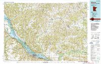
1985 Map of Winona
USGS Topo · Published 1989About this map
The Mississippi River valley dominates this mid-1980s landscape, serving as the border between Minnesota and Wisconsin and a major corridor for the Chicago and North Western and Burlington Northern railroads. On the Minnesota side, the city of Winona is flanked by the distinctive Sugarloaf landmark and Lake Winona, while the expansive Upper Mississippi River Wild Life and Fish Refuge covers the intricate network of islands and backwaters. Across the river in Wisconsin, the terrain transitions into the steep ridges and deep coulees of the Driftless Area, including Montana Ridge and Waumandee Ridge. The map details agricultural centers like Arcadia and Whitehall alongside protected lands such as the Trempealeau National Wildlife Refuge. This survey captures the region's complex mix of river-based commerce, rail infrastructure, and conservation areas before modern developments altered these riparian habitats.
Find a feature on this map
94 named features on this map. Tap any name to fly to it.
Don’t see what you’re looking for? This feature index may not catch every label — zoom into the map to look around manually.
Map Details
Editions of this 1985 Winona Map
2 editions found
Other maps of this area

1909 · Sparta
USGS Topo · 1:62,500

1924 · Black River Falls
USGS Topo · 1:62,500

1926 · Black River Falls
USGS Topo · 1:62,500

1926 · North Bend
USGS Topo · 1:62,500

1926 · Whitehall
USGS Topo · 1:62,500

1927 · Blair
USGS Topo · 1:62,500

1927 · La Crosse
USGS Topo · 1:62,500

1927 · Strum
USGS Topo · 1:62,500

1928 · Melrose
USGS Topo · 1:48,000

1929 · Whitehall
USGS Topo · 1:62,500