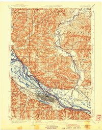
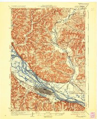
1937 Map of Winona
USGS Topo · Published 1944About this map
The Mississippi River corridor dominates this 1930s landscape, revealing a complex network of backwaters and islands such as Island No 65 and Island No 66 before modern channelization fully altered the Upper Mississippi. On the Minnesota side, Winona stands as a significant rail and industrial hub, with the Chicago Milwaukee St Paul and Pacific and the Chicago and Northwestern railroads converging at the river's edge. The presence of Lock and Dam No 5A signifies the era's massive engineering efforts to manage navigation and flood control.
Find a feature on this map
98 named features on this map. Tap any name to fly to it.
Don’t see what you’re looking for? This feature index may not catch every label — zoom into the map to look around manually.
Map Details
Editions of this 1937 Winona Map
3 editions found

Other maps of this area

1926 · Whitehall
USGS Topo · 1:62,500

1929 · Whitehall
USGS Topo · 1:62,500

1929 · Fountain City
USGS Topo · 1:62,500

1929 · Galesville
USGS Topo · 1:62,500

1930 · La Crescent
USGS Topo · 1:62,500

1932 · Cochrane
USGS Topo · 1:62,500

1932 · Gilmanton
USGS Topo · 1:62,500

1932 · Alma
USGS Topo · 1:62,500

1934 · Winona
USGS Topo · 1:62,500

1934 · Cochrane
USGS Topo · 1:62,500