1937 Map of Winona
USGS Topo · Published 1937About this map
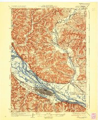
Winona stands as a dense grid at the heart of this riverine landscape, positioned between the Mississippi River and the sweeping curve of Lake Winona. The city's 1930s infrastructure is clearly defined, featuring the massive Biesanz Quarry and the campus of St Marys College. The surrounding terrain is a complex network of sloughs and channels, including Straight Slough and Indian Channe, which separate numerous numbered islands like Island No 63 and Island No 64.
Find a feature on this map
78 named features on this map. Tap any name to fly to it.
Don’t see what you’re looking for? This feature index may not catch every label — zoom into the map to look around manually.
Map Details
Editions of this 1937 Winona Map
3 editions found

Other maps of this area

1926 · Whitehall
USGS Topo · 1:62,500

1929 · Whitehall
USGS Topo · 1:62,500

1929 · Fountain City
USGS Topo · 1:62,500

1929 · Galesville
USGS Topo · 1:62,500

1930 · La Crescent
USGS Topo · 1:62,500

1932 · Cochrane
USGS Topo · 1:62,500

1932 · Gilmanton
USGS Topo · 1:62,500

1932 · Alma
USGS Topo · 1:62,500

1934 · Winona
USGS Topo · 1:62,500

1934 · Cochrane
USGS Topo · 1:62,500