1998 Map of Winstead Crossroads
USGS Topo · Published 2001About this map
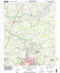
The Tar River winds through the northern portion of this landscape, its course spanned by the Cockrell Bridge and bordered by small communities such as Winstead Crossroads and Cliftonville. In the southern reach, the urban expansion of Wilson is evident, characterized by established neighborhoods and local institutions like Ralph L Fike High Sch and Evergreen Memorial Gardens. The area is notably defined by its numerous rural congregations, including Mt Hermon Ch, Rick Grove Ch, and Gethsemane Ch, which served as anchors for the surrounding crossroads settlements. Significant water features like Silver Lake and Lake Wilson are prominent, while the Toisnot Swamp and Bloomery Swamp drainage systems indicate the low-lying, well-watered geography of the coastal plain. Transport and utility infrastructure is well-represented by the Rocky Mount-Wilson Airport and Interchange 127, marking the intersection of regional commerce and local community life.
Find a feature on this map
44 named features on this map. Tap any name to fly to it.
Don’t see what you’re looking for? This feature index may not catch every label — zoom into the map to look around manually.
Map Details
Editions of this 1998 Winstead Crossroads Map
This is the sole edition of this map. No revisions or reprints were ever made.
Other maps of this area

1902 · Kenly
USGS Topo · 1:62,500

1902 · Rocky Mount
USGS Topo · 1:62,500

1902 · Spring Hope
USGS Topo · 1:62,500

1903 · Kenly
USGS Topo · 1:62,500

1904 · Rocky Mount
USGS Topo · 1:62,500

1904 · Springhope
USGS Topo · 1:62,500

1904 · Wilson
USGS Topo · 1:62,500

1953 · Rocky Mount
USGS Topo · 1:250,000

1953 · Raleigh
USGS Topo · 1:250,000

1954 · Rocky Mount
USGS Topo · 1:250,000