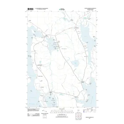
2011 Map of Winter Harbor
USGS Topo · Published 2011About this map
Winter Harbor and the surrounding villages of Gouldsboro define this coastal landscape on the Schoodic Peninsula. The map details a maritime economy and community layout, from the Winter Harbor Marina and Grindstone Neck Golf Course in the south to the Bartlett Maine Estate Winery near Lower West Bay Pond in the north. Local heritage is preserved in sites like Hillside Cemetery and Hillcrest Cemetery, while the rugged shoreline is dotted with named ledges and islands such as Big Sugar Bear Island and Sargents Island. The settlement pattern follows the intricate coastline, connecting South Gouldsboro, Birch Harbor, and Prospect Harbor via a network of local roads that skirt geographic features like Winn Joy Mountain and Ash Mountain. This 2011 survey documents the established balance between seasonal recreation and year-round coastal residency.
Find a feature on this map
124 named features on this map. Tap any name to fly to it.
Don’t see what you’re looking for? This feature index may not catch every label — zoom into the map to look around manually.
Map Details
Editions of this 2011 Winter Harbor Map
This is the sole edition of this map. No revisions or reprints were ever made.
Other maps of this area

1902 · Cherryfield
USGS Topo · 1:62,500

1904 · Cherryfield
USGS Topo · 1:62,500

1904 · Bar Harbor
USGS Topo · 1:62,500

1904 · Petit Manan
USGS Topo · 1:62,500

1930 · Tunk Lake
USGS Topo · 1:48,000

1932 · Tunk Lake
USGS Topo · 1:62,500

1942 · Bar Harbor
USGS Topo · 1:62,500

1942 · Cherryfield
USGS Topo · 1:62,500

1942 · Tunk Lake
USGS Topo · 1:62,500

1948 · Bangor
USGS Topo · 1:250,000