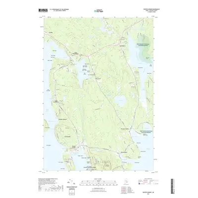
2021 Map of Winter Harbor
USGS Topo · Published 2021About this map
Winter Harbor and the Schoodic Peninsula anchor this coastal survey, where the rugged Maine shoreline is punctuated by sheltered coves and rocky points. The landscape is a mix of small villages like Birch Harbor and Prospect Harbor, and protected federal lands including segments of Acadia National Park and the Petit Manan National Wildlife Refuge. For genealogists, the map is particularly dense with small family burial grounds such as the Nahum Jones Cem and Hillside Cem, which sit alongside historic road corridors like Old Rte 1. From the elevations of Winn Joy Mtn to the tidal reaches of Grand Marsh Bay, the map documents the geographic relationship between the peninsula's coastal settlements and its interior heaths and ponds like Goose Pond Heath and Forbes Pond.
Find a feature on this map
150 named features on this map. Tap any name to fly to it.
Don’t see what you’re looking for? This feature index may not catch every label — zoom into the map to look around manually.
Map Details
Editions of this 2021 Winter Harbor Map
This is the sole edition of this map. No revisions or reprints were ever made.
Other maps of this area

1902 · Cherryfield
USGS Topo · 1:62,500

1904 · Cherryfield
USGS Topo · 1:62,500

1904 · Bar Harbor
USGS Topo · 1:62,500

1904 · Petit Manan
USGS Topo · 1:62,500

1930 · Tunk Lake
USGS Topo · 1:48,000

1932 · Tunk Lake
USGS Topo · 1:62,500

1942 · Bar Harbor
USGS Topo · 1:62,500

1942 · Cherryfield
USGS Topo · 1:62,500

1942 · Tunk Lake
USGS Topo · 1:62,500

1948 · Bangor
USGS Topo · 1:250,000