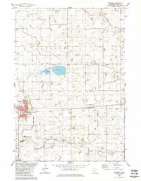
1982 Map of Winthrop
USGS Topo · Published 1983About this map
Winthrop serves as the primary hub of this Sibley County landscape, situated at the junction of the Chicago and North Western railroad and significant regional roadways. The surrounding terrain in Transit and Alfsborg townships is defined by an extensive network of drainage projects, including Judicial Ditch No 18 and Ditch No 40, which transformed former wetlands into productive agricultural territory. This conversion is evidenced by several named dry basins like Allen Lakebed and Mud Lakebed.
Find a feature on this map
29 named features on this map. Tap any name to fly to it.
Don’t see what you’re looking for? This feature index may not catch every label — zoom into the map to look around manually.
Map Details
Editions of this 1982 Winthrop Map
This is the sole edition of this map. No revisions or reprints were ever made.
Other maps of this area

1953 · New Ulm
USGS Topo · 1:250,000

1957 · New Ulm
USGS Topo · 1:250,000

1958 · New Ulm
USGS Topo · 1:250,000

1958 · Gaylord
USGS Topo · 1:62,500

1958 · Winthrop
USGS Topo · 1:62,500

1964 · Bernadotte
USGS Topo · 1:24,000

1964 · Lafayette
USGS Topo · 1:24,000

1965 · New Sweden
USGS Topo · 1:24,000

1967 · New Ulm
USGS Topo · 1:250,000
1982 · Winthrop SW
USGS Topo · 1:24,000